


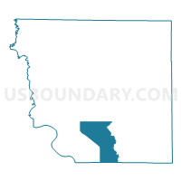
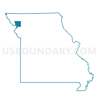
Beeler Voting District, Andrew County, Missouri
About
Outline

Summary
| Unique Area Identifier | 607022 |
| Name | Beeler Voting District |
| County | Andrew County |
| State | Missouri |
| Area (square miles) | 19.05 |
| Land Area (square miles) | 18.86 |
| Water Area (square miles) | 0.20 |
| % of Land Area | 98.97 |
| % of Water Area | 1.03 |
| Latitude of the Internal Point | 39.87451630 |
| Longtitude of the Internal Point | -94.79894290 |
Maps

Graphs
Select a template below for downloading or customizing gragh for Beeler Voting District, Andrew County, Missouri


Neighbors
Neighoring Voting District (by Name) Neighboring Voting District on the Map
- Voting District 11-B, Buchanan County, MO
- Voting District 16-H, Buchanan County, MO
- Country Club Voting District, Andrew County, MO
- John Glenn Voting District, Andrew County, MO
- John Glenn A Voting District, Andrew County, MO
- Lincoln Voting District, Andrew County, MO
- Monroe West Voting District, Andrew County, MO
- Rochester Voting District, Andrew County, MO
- Savannah Southeast Voting District, Andrew County, MO
- Savannah Southwest Voting District, Andrew County, MO
Top 10 Neighboring County Subdivision (by Population) Neighboring County Subdivision on the Map
- Washington township, Buchanan County, MO (78,865)
- Nodaway township, Andrew County, MO (6,738)
- Jefferson township, Andrew County, MO (4,646)
- Lincoln township, Andrew County, MO (1,184)
- Rochester township, Andrew County, MO (1,182)
- Monroe township, Andrew County, MO (793)
Top 10 Neighboring Place (by Population) Neighboring Place on the Map
Top 10 Neighboring Elementary School District (by Population) Neighboring Elementary School District on the Map
Top 10 Neighboring Unified School District (by Population) Neighboring Unified School District on the Map
Top 10 Neighboring State Legislative District Lower Chamber (by Population) Neighboring State Legislative District Lower Chamber on the Map
Top 10 Neighboring State Legislative District Upper Chamber (by Population) Neighboring State Legislative District Upper Chamber on the Map
Top 10 Neighboring 111th Congressional District (by Population) Neighboring 111th Congressional District on the Map
Top 10 Neighboring Census Tract (by Population) Neighboring Census Tract on the Map
- Census Tract 102, Andrew County, MO (6,738)
- Census Tract 101, Andrew County, MO (5,439)
- Census Tract 1, Buchanan County, MO (5,397)
- Census Tract 27, Buchanan County, MO (3,327)
- Census Tract 104, Andrew County, MO (3,051)
- Census Tract 103, Andrew County, MO (2,063)